As climate change and global uncertainty accelerate risk, the need for smarter, faster decisions about critical infrastructure has never been greater. Envicom is proud to launch our new Resilience & Infrastructure service line, powered by our spatial intelligence platform, Ground Truth. We help you ๐ณ๐ฆ๐ต๐ฉ๐ช๐ฏ๐ฌ ๐ธ๐ฉ๐ฆ๐ณ๐ฆ ๐ข๐ฏ๐ฅ ๐ฉ๐ฐ๐ธ you plan, prioritize, and implement your projects.
๐ฃ๐น๐ฎ๐ป๐ป๐ถ๐ป๐ด ๐๐ถ๐๐ต ๐ฃ๐ฟ๐ฒ๐ฐ๐ถ๐๐ถ๐ผ๐ป
With more than 50 years of geospatial and land use expertise, Envicom understands that where is just as important as what. Ground Truth pinpoints risk hotspots and resilience opportunities early, streamlining feasibility, reducing costs, and strengthening outcomes.
๐ข๐ฝ๐ฒ๐ฟ๐ฎ๐๐ถ๐ผ๐ป๐ฎ๐น ๐ฅ๐ฒ๐๐ถ๐น๐ถ๐ฒ๐ป๐ฐ๐ฒ
Ground Truth also supports real-time operations, including debris removal and hazardous waste management, helping communities respond faster and recover stronger.
๐ฆ๐ฐ๐ฎ๐น๐ฎ๐ฏ๐น๐ฒ ๐ฆ๐ผ๐น๐๐๐ถ๐ผ๐ป๐, ๐๐น๐ผ๐ฏ๐ฎ๐น ๐๐บ๐ฝ๐ฎ๐ฐ๐
From government agencies to private developers and multilateral organizations, Ground Truth provides the intelligence needed to plan, fund, and implement resilient infrastructure exactly where it matters most.
At Envicom, we are ready to support your goals from planning through implementation. Letโs build smarter, stronger, and more resilient systems together.
Unearthed in the Field!
Nine million year-old Miocene marine shells have just been uncovered by our San Pedro High School project team, led by Wayne Bischoff, PhD. Working in close collaboration with Dr. Austin Hendy at the Natural History Museum of Los Angeles County, Envicom is particularly excited by this discovery - only the second ever recorded invertebrate fossils this old to be found on the Palos Verdes Peninsula.
This discovery provides a rare glimpse into Southern California's ancient marine environments and will support future paleontological research. Envicom is proud to advance scientific discovery while ensuring that progress and preservation go hand in hand.
Archaeological and Paleontological Monitors Needed for Southern California Projects
Archaeological and Paleontological Monitors Needed for Southern California Projects // Location Areas: Los Angeles Basin, Ventura and Riverside County, as well as the San Fernando Valley Region.
Envicom Corporation (Envicom) is looking for on-call archaeological and paleontological monitors to assist with construction monitoring at various project sites in Southern California. Candidates must have a bachelorโs degree in archaeology, paleontology, or geology. Candidates should have a minimum of one year of experience working with construction projects and heavy equipment. Candidates should also have direct experience identifying artifacts and/or paleontological materials during construction and be confident in communicating with and directing construction crews as necessary. Preferred candidates would have a basic understanding of state laws, regulations, standards, and guidelines governing cultural and/or paleontological resources.
Envicom offers competitive compensation for this position on an hourly basis. Per diem and other compensation is also offered on a project-by-project basis.
Send Resumes to: rlmauro@envicomcorporation.com
San Pedro High School Update: Sea Turtle Gastroliths Recovered
Excavation continues at the site of a nine-million-year-old marine bone bed beneath Los Angeles Unified School Districtโs San Pedro High School. Our paleontology team recently uncovered a collection of gastroliths, the water-worn stomach stones used by sea turtles for digestion and buoyancy, likely deposited near what was once an offshore island off the California coast.
Analysis is now underway to determine whether these ancient turtles selected stones based on size, shape, or color. This ongoing project is led by Wayne Bischoff, Envicomโs Director of Cultural Resources.
As cultural monitoring continues, Envicom remains committed to keeping projects moving forward while protecting what lies beneath.
California CEQA Reforms Update
On June 30, Governor Newsom signed AB 130 and SB 131 into law, bringing major updates to the California Environmental Quality Act (CEQA).
Key Changes Include (Primarily from SB 131):
New CEQA Exemptions
โข Rezoning aligned with certified housing elements
โข Agricultural employee housing and repairs to existing farmworker housing
โข Water and sewer infrastructure projects for disadvantaged communities (exemption extended to 2032)
โข Wildfire risk reduction projects including prescribed burns and fuel breaks
โข Linear broadband deployment in local road rights-of-way
โข Climate adaptation strategy updates
โข Development of public parks and nonmotorized recreational trails (state-funded)
โข Facilities such as day care centers, nonprofit food banks, health clinics, and advanced manufacturing (not on protected lands)
โข High-speed rail maintenance and station facilities
Targeted CEQA Review
โข If a project is exempt except for one disqualifying condition, CEQA analysis is limited solely to that condition
โข Does not apply to projects involving distribution centers, oil/gas infrastructure, or located on protected lands
Administrative Record Reform
โข Internal agency staff notes and communications are excluded from the CEQA administrative record (except for distribution centers and oil/gas infrastructure)
Infill and Urban Development Streamlining
โข State to map eligible urban infill sites
โข CEQA EIRs for infill projects limited to new or more significant effects not covered in prior EIRs
Guideline Reforms
โข CEQA implementation guidelines to be updated at least every two years to address ambiguities and reduce frivolous litigation
Purpose of These Reforms
These reforms were designed to accelerate housing production, streamline environmental review, and reduce delays for critical infrastructure and public service projects, especially in already developed areas.
What This Means for Projects
Projects that previously required full CEQA review may now qualify for exemption or limited-scope analysis. This can reduce time, cost, and litigation risk during planning and permitting.
How Envicom Can Help
With the recent passage of these bills, specific guidance on implementation of these reforms is still being developed. Envicom is working to stay ahead of the curve to inform our practices and how best to assist our clients with how to take advantage of these monumental streamlining opportunities. Weโre helping our public agencies and private industry clients interpret these changes, validate eligibility, and adapt project strategies to align with these updates.
Do you have questions about your project and want to speak with a CEQA expert? Feel free to contact:
Travis Cullen, President: tcullen@envicomcorporation.com
Laura Kaufman, AICP, Vice President: lkaufman@envicomcorporation.com
Coyote Spotted Outside Envicom Office Highlights Urban Wildlife Patterns
Earlier today, a coyote wandered through our Westlake Village parking lot, a reminder of how close nature is, even in developed areas.
Though coyotes are naturally elusive, sightings like this are becoming more common across Southern California. Habitat fragmentation, reduced food sources, and drought-driven ecosystem changes can increase their presence in developed areas.
Our Biological Resources team works with clients to assess habitat conditions, identify sensitive species, and support project designs that reduce wildlife conflicts.
Water Resilience Planning in Somaliland: A GIS-Based Approach
Somaliland regularly faces severe water scarcity, with no perennial rivers and increasing pressure on groundwater and surface water sources. Recurrent droughts have caused significant water shortages for people and livestock, which make up about 70% of Somalilandโs GDP. In response, Pharo Foundation has enacted a 'grand strategy' for developing rainwater harvesting infrastructure at scale to build resilience and improve water access in underserved areas of the entire region.
Envicom supported this effort, with our GIS Services Manager Amanda Miner leading the geospatial site suitability analysis, to identify the optimal locations for new water infrastructure. Our analysis considered geographic, hydrological, meteorological, and socioeconomic factors to ensure critical grazing land access was in proximity to new water access.
This work is part of Envicomโs ongoing efforts to support resilience and infrastructure planning through practical, data-driven solutions that consider human needs, ecological conditions, and economic realities.
Weโre excited to announce that Envicom now offers Resilience & Infrastructure Planning as a new service area, expanding how we help clients manage risk, protect critical resources, and plan for long-term environmental and infrastructure challenges.
Protecting Sensitive Species with Trail Camera Monitoring
Footage captured during a wildlife camera monitoring effort in the pre construction phase of a large-scale solar project in the Mojave Desert. Led by staff biologist Jamie Perigo, Envicom supported the project with special status species surveys and monitoring to protect sensitive desert wildlife.
The video features a mated pair of desert kit foxes (Vulpes macrotis arsipus), an American badger (Taxidea taxus), and a burrowing owl (Athene cunicularia), which is a protected species under state and federal law.
Surveys included identifying and mapping burrows suitable for special status species using our in-house GIS system. Active burrows were confirmed through field signs such as scat, feathers, whitewash, fresh dig marks, and trail camera data. Burrow activity was monitored to establish appropriate buffers and prevent disturbance during construction.
Our team is experienced in wildlife camera monitoring and ready to assist when needed.
Habitat Restoration in Malibu Supports Native Bird Nesting
While surveying one of our habitat restoration sites in Malibu, Envicom Staff Biologist Cameron Cesa discovered a lesser goldfinch nest tucked within a thriving mulefat shrub.
This small but meaningful finding highlights the ecological value of restoring previously degraded habitats. Not only do these efforts improve landscape health, but they also provide critical nesting and foraging space for native wildlife.
Every restored site tells a story of resilience, and each nest is a sign weโre moving in the right direction.
Will AI Affect Environmental Consulting? It Already Has.
Infrared image of Malibu. Source: Valtus Imagery Services, Hexagon Imaging Program (HxIP), 2023
Written by Mina Nada
AI isnโt going to rewrite Californiaโs environmental laws.
CEQA isnโt going anywhere. Jurisdictional reviews, site-specific studies, and mitigation plans will still need to be written, reviewed, revised, and defended.
But AI is changing how we do the work. Not in flashy headlines. Not in speculative think pieces. But in the day-to-day workflows, the ones that separate a good environmental consulting firm from a great one.
At Envicom Corporation, weโre not asking โHow will AI change GIS?โ
Weโre asking โHow can we use it to make our work better today?โ
And the answer, more often than not, is quietly powerful.
Efficiency with Integrity
AIโs impact on GIS (and environmental consulting more broadly) isnโt just about saving time. Itโs about reallocating time.
When you automate routine, rules-based tasks, you're not just shaving hours off a project; youโre buying back clarity, focus, and quality.
Youโre freeing up your GIS analyst to focus on symbology and clarity in map design. You're giving your bio team more time to synthesize their site observations into clearer assessments. You're allowing your paleo and cultural experts to spend more time interpreting history, not formatting reports. But none of this works if the AI tools we use arenโt built on precision.
Thatโs why every day, we put our ego aside and ask a simple question:
Is this the right tool for the right job?
Thatโs it. Thatโs the core practice.
Because using AI is not a flex. Itโs not a pitch. Itโs a means to an end. Our clients donโt care if we used an LLM or a GPT.
Letโs Talk About the Tree Model
Take our tree model. Instead of manually identifying and digitizing tree locations, we developed an in-house AI model to automatically generate tree canopies for our tree reports from the data collected by our biologists.
What used to take days can now be turned around in hours, leaving our team more time for analysis and decision-making, not rote digitization. When you're working in regulated environments like California, speed isnโt a luxury, itโs a necessity.
Agencies (US Forest Service, CA Dept. of Fish & Wildlife), clients (housing developers), and county governments alike expect clean data, accurate assessments, and defensible reports. If you're slow, youโre out. If you're inaccurate, you're done.
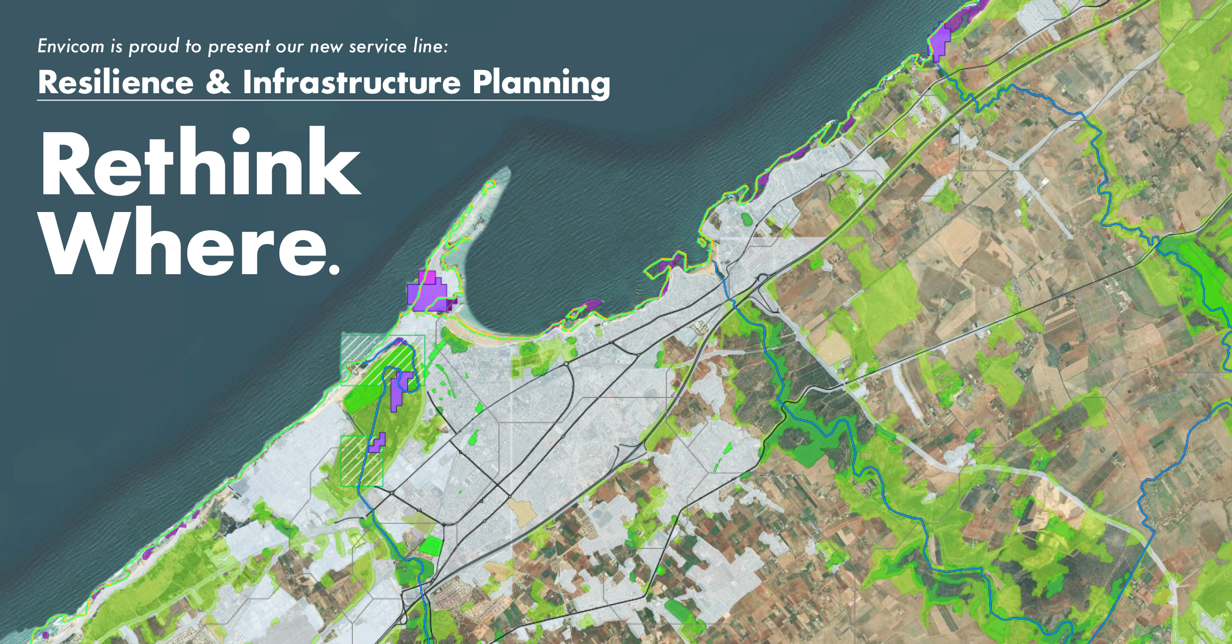
This example below is the type of map we can automate specific geospatial tasks:
An example of a Tree Impacts Map for a development project
So we can focus our work on refining other end-use products like this:
An example of resilience mapping for grazing suitability
Supporting the Whole Team, Not Just the Map
As a geospatial analyst, I see the final map product as a mirror, in that it reflects every step of the process. The better we automate data cleaning, field data integration, or imagery classification, the more time I can spend making maps that communicate. That tell a story clearly, at the right scale, for the right decision-makers.
But this goes beyond mapping.
We use AI tools to support our biologists, not replace their judgment. Our automation helps them identify patterns, surface key indicators faster, and navigate dense datasets easier.
We use AI to help our paleo and cultural teams structure their reports and pull from large corpuses of past records, before a site visit ever happens.
And we donโt shout about it.
Because the goal is not to prove we use AI. The goal is to improve the outcome.
We stay competitive by being efficient. But we stay relevant by being right.
What Clients Actually Care About
No client has ever asked us which deep learning model we used. They ask:
โIs this accurate?โ
โDoes this report complete my permitting requirements?โ
โWill this hold up under review?โ
They care that our wetland delineation map is accurate. That our report holds up in permitting meetings. That our analysis helps them move forward with confidence. The technology supports the work. It doesnโt define it.
Thatโs the lighthouse. Not the tech. The accuracy of our environmental analysis. Thatโs how we serve our clients and our community. AI helps us get there. Faster, yes. But also with more confidence.
Because when used well, AI doesnโt replace expertise, it amplifies it.
Developing in-house web-mapping applications for analyzing market size with geospatial data
Letโs Work Together
If youโre looking for environmental services that prioritize accuracy, efficiency, and regulatory compliance, without the fluff, weโd love to connect. Whether it's biological surveys, GIS support, or full-scope CEQA/NEPA documentation, our team is here to get the job done right.
Feel free to reach out to me directly, or contact Travis Cullen at tcullen@envicomcorporation.com to learn more about how we can support your next project.
Letโs build smarter solutions, together.
Update from the San Pedro High School Fossil Excavation
San Pedro High School Update: Envicom team members, Rowan Barton, Lauren Castaneda, and Sophia Muller, along with Los Angeles Unified School District team member Christy Wong, excavate within a nine-million-year-old marine fossil bone bed layer, found earlier this year.
To date, the LAUSD San Pedro High School site (featured on NPR, the LA Times, KCAL News and many others) has provided a wealth of information about Southern California's paleontological past, including four different Late Miocene bone bed layers. Dr. Wayne Bischoff (Envicom's Director of Cultural Resources) and his team, have discovered many marine fossils at the site, including fossils from extinct dolphins, whales, sea lions, sharks, sea turtles, marine birds, invertebrates, and lots of fish!
Envicom Supports the First Ever National Park Service Fossil Day Event!
In support of the National Park Serviceโs first ever Fossil Day event, the NPS and the Natural History Museum of Los Angeles County asked Envicom to be a presenter at the Santa Monica Mountains National Recreation Area visitor center. Envicom presented information from their LAUSD San Pedro High School discovery of several Late Miocene marine bonebeds with millions of fish, shark, sea turtle, and shore bird bones, as well as thousands of coprolites (fossil animal feces). School children and their parents were able to participate in cleaning the coprolites and looking at what they contain under a digital microscope. Hundreds of small fish and invertebrate bones are in the coprolites, eaten by dolphins, sharks, and other marine animals 9-million years ago, including by megalodon sharks, the largest sharks that ever existed!
Envicom Team Finds Treasure Trove of Marine Fossils Found Under San Pedro High School!
Dr. Wayne Bischoff (Envicom Corporation - Director of Cultural Resources) pictured with Dr. Austin Hendy (Natural History Museum - Assistant Curator) and Milad Esfahani (San Pedro - Student).
Envicom Corporation is supporting a construction project at San Pedro High School that uncovered a significant collection of marine fossils. Some date back over 9 million years, to a time when the Palos Verdes Peninsula was underwater.
Envicomโs Paleontologist & Archaeologist, Nicole Diem.
Fossilized vertebra from an extinct dolphin species.
Envicom discovered in 2023 the largest marine fossil bonebed in Los Angeles and Orange Counties. Dr. Wayne Bischoff of Envicom has been working with staff from the Natural History Museum of Los Angles County to document the Late Miocene (8.7-million years ago) discovery. The millions of fossils found at the discovery site came from fish, sharks, dolphins, whales, sea turtles, seabirds, invertebrates, and ocean and shore plants. Many of the species discovered are now extinct, but many can still be found off Californiaโs coast today.
As part of the discovery response, fossil rocks and samples will be provided to several educational institutions, including the Cabrillo Aquarium, for public display, interpretation, and education. Six large fossil rocks were recently set up in the Aquariumโs public garden, which was announced in the Bulletin of the Southern California Paleontological Society. Dr. Bischoff and Dr. Austin Hendy of the Natural History Museum will also be talking about the discovery at the Natural History Museum on February 4th , 2024.
Links to Articles/Features
BBC News (Spetember 19, 2024)
The Guardian (Great Britain Newspaper)
LA Times (September 13, 2024)
Business Today (Indiaโs business news magazine)
WPLG Local 10 (ABC Network affiliate in Miami)
NY Post (September 11, 2024)
Yahoo News (September 10, 2024)
AOL.com (September 10, 2024)
LAUSD Press Conference (September 9, 2024)
FOX 11 News (Fossils Interview)
KCAL/KCBS News (Broadcast Clip)
LAist (September 9, 2024)
Daily Breeze (September 11, 2024)
Nexus Project News: August 2024
Water for Good is tackling water poverty in one of the worldโs most forgotten countries. They have a tough, but very determined mission: to provide clean, lasting water to every man, woman, and child in the Central African Republic. When they first reached out to us, their team was seeking to improve their mapping capabilities and integrate multiple data tools for collecting, processing, and mapping into one comprehensive platform. They wanted data to be accessible to their entire team.
Water for Good knows their data, and it is complex. Their program spans approximately two-thirds of the Central African Republic. They have extensive maintenance program data, complex engineering metrics, demographic analytics, and no shortage of planning data. This team is very data savvy and highly experienced in what they do.
So, what was missing?
ยท The ability to map and display drone data and understand topographical context
ยท The ability to map and manage piped networks and general infrastructure
ยท The ability to measure water infrastructure provisions as a proportion of area and population.
ยท A method for displaying and automating engineering and trip planning metrics
ยท A shared, integrated platform for all team members
Hereโs how weโve begun to fill those gaps for them with our Nexus platform:
Nexus is a highly configurable platform for creating geospatial web and mobile apps with offline/ sync capability. It is built on creative open source technology by our talented partners at MapGears.
Restoring Oak Canyon Pond Post-Woolsey Fire
The Oak Canyon Community Park Duck Pond, located within Oak Canyon, was burned and damaged during the 2018 Woolsey Fire and during subsequent winter rains, sediment, ash and debris washed down into and filled the ponds, culvert and Medea Creek channel. The Oak Canyon Community Park Duck Pond Project, led by the Rancho Simi Recreation and Parks District (RSRPD), aims to restore the pond area to pre-Woolsey fire conditions.
There are a different species that previously resided in the Oak Canyon Pond, including the red eared slider, and southwestern pond turtle. The Southwestern pond turtle (Emys marmorata) is a native turtle species and is threatened by the invasive red eared slider (Trachemys scripta elegans) which often compete with southwestern pond turtles for food and transmit diseases. One of the Project goals was to round-up turtles prior to initiation of construction and transport any non-native red eared sliders to a turtle sanctuary in Arroyo Grande, and relocate southwestern pond turtles with the assistance of a designated biologist and turtle expert.
On June 30, 2022, Envicom assisted over a dozen community volunteers and Park staff members in a turtle round-up. Volunteers geared up in rubber boots and gloves, and waded through the mud-soaked pond area to round up any turtles with hand nets. Multiple red-eared sliders were captured during the round-up for transfer to the sanctuary, and the biologist provided turtle education for local volunteers.
Envicom's GIS Team Assists with COVID-19 Mapping Project
GISCorps is an organization that coordinates the voluntary assistance of short-term, highly specialized GIS expertise to improve the well being of developing and transitional communities. Envicom's GIS team has provided their skills on multiple GISCorps projects over the past few years, and so were glad to respond when we received their Mission Recruiting Announcement at the end of March. The request to GISCorps came from ESRI's Disaster Response Team, who need assistance to create and maintain a nationwide dataset of all COVID-19 testing locations, along with up-to-date instructions and information pertinent to each testing site. Envicom's GIS team has adopted Ventura County, CA and we will maintain this important information for our home county until this crisis is over. Public access to COVID-19 Testing Site information is available here.